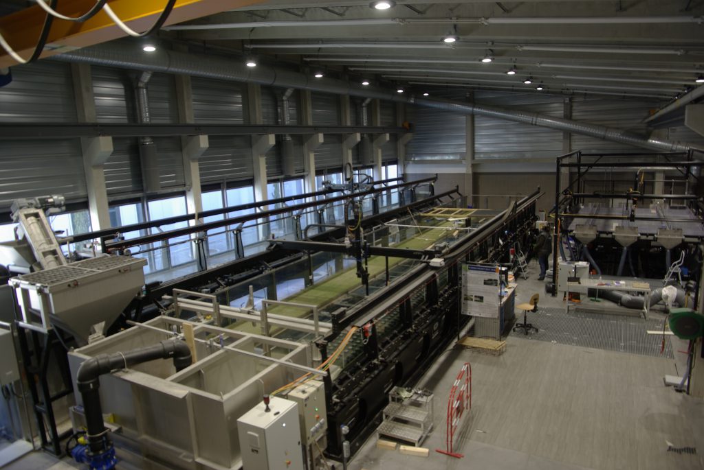
The Hydraulic and Hydromorphology Laboratory (HHLab) is a platform of 350 m² that includes three physical models (built and equipped from 2013 to 2017). This platform is dedicated to the study of physical processes associated with river flows or flows in a highly anthropized environment.
The three facilities are
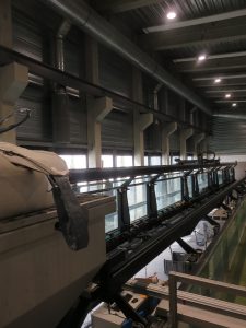
- A wide flume, 3 m-wide, 18 m-long, 80 cm-deep, with a fixed bed slope of 1/1000.
- A tilting flume, 1 m-wide, 18 m-long, 80 cm-deep, with a maximum bed slope of 5 %.
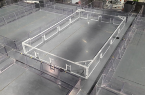
- An urban flood model (MURI), 5.4 m-long, 3.8 m-wide, with maximum slopes of 5 % in the longitudinal and transverse directions.
Characteristics of the physical models
| Wide flume | Tilting flume | MURI | |
| Total length | 18 m | 18 m | 5.4 m |
| Width | 3 m | 1 m | 3.8 m |
| Height | 80 cm | 80 cm | 15 cm |
| Inlet conditions | 3 independant inlet tanks | 1 inlet tank | 1 to 9 inlet tanks |
| Maximum discharge |
300 L.s-1 (75 L.s-1 + 150 L.s-1 + 75 L.s-1) |
150 L.s-1 | 50 L.s-1 to be shared between 1 to 9 inlets |
| Outlet conditions | 3 adjustable tail weirs | 1 adjustable tail weir | 3 adjustable tail weirs+ 3 outlet tanks |
| Maximum bed slope | 1/1000 | 5/100 | 5/100 in both directions |
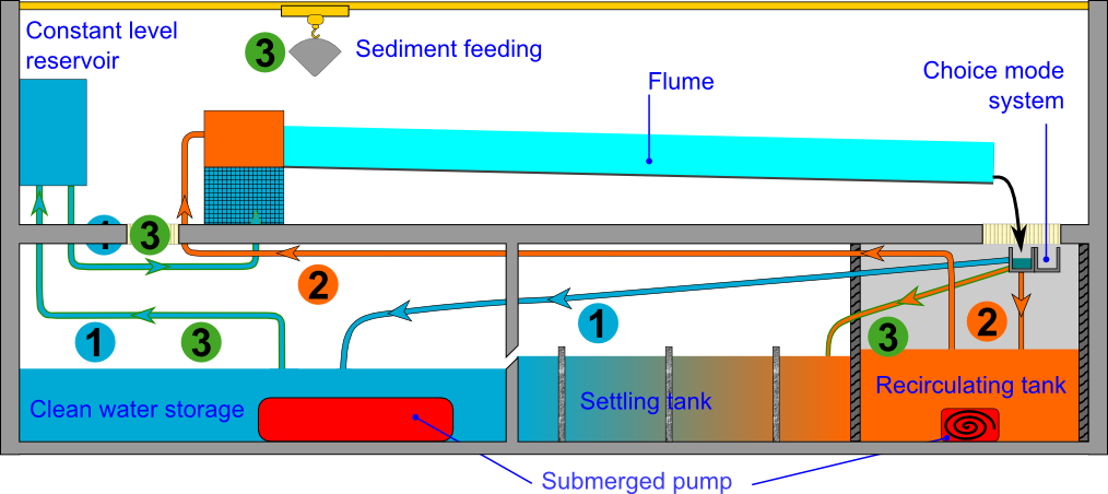
Water and sediment supply
The two long flumes (wide and tilting) are supplied in in three different ways:
- Clean water can be supplied through a constant head water tower. The water is then recycled in a basement area.
- Sediment (diameter < 1 mm) laden water can also be supplied in a close loop. The water is recycled in another smaller basement area equipped with stirrer to homogenize the sediment concentration.
- Finally, it is possible to work in an open configuration for coarse sediment. The sediment settles in an intermediate tank. The flumes are fed in sediment independently of the water.
The scheme below illustrated these different modes:
Instrumentation
Several sensors are deployed:
- Ultrasound sensors to measure free-surface elevation (9 sensors, 3 up-stream, 3 downstream, 3 mobile),
- Discharge measurements with an electromagnetic flowmeter at the entrance of the flume.
- Velocity measurements (Pitot tube, Acoustic Doppler Velocimeter, and PIV systems).
- Topographic measurements with a 2D laser scan (submillimetrical resolution, Scan-Control 2900-100)
- Pictures.
These sensors are fixed to a motorized trolley and can be moved automatically.
Research subjects
We use these facilities to address multiple issues such as :
- vegetated flows
- shear flows (compound channels and mixing layers),
- transverse waves in stationary flows,
- urban floods,
- interactions between sediments of different sizes,
- alternated bars dynamics,
- unsteady flows
Publications
PhD and HdR Theses
- MEJIA MORALE, M.A. – 2022. Influence of the flow exchanges between streets and a city block during urban floods: a laboratory: Laboratory experiments under steady and unsteady flow conditions
Thèse de doctorat de l’Université de Lyon, opérée à l’Institut National des Sciences Appliquées. ⟨tel-03806407⟩ - KADDI, Y. – 2021. Modélisation 1D par lit (ISM) d’un réseau hydraulique ramifié maillé : application au contexte opérationnel de la prévision des fortes crues et des crues de dimensionnement d’ouvrages. Thèse de doctorat. Mécanique des fluides. Université de Lyon. ⟨NNT : 2021LYSE1200⟩. ⟨tel-03637028⟩
- OUKACINE, M. – 2019. Étude expérimentale et numérique d’écoulements à surface libre en présence d’obstacles émergés et faiblement submergés. Thèse de doctorat, Mécaniques des fluides, Université de Paris Est. 231 p.
- PERRET, E. – 2017. Transport of moderately sorted gravels at low bed shear stresses: impact of bed arrangement and fine sediment infiltration. Thèse de doctorat, Mécaniques des fluides, Université de Lyon. 378 p.
- DUPUIS, V. – 2016. Experimental investigation of flows subjected to a longitudinal transition in hydraulic roughness in single and compound channels. Thèse de doctorat, spécialité : Mécanique des fluides, Université Lyon I Claude Bernard. 141 p.
- PROUST, S. – 2015. Steady non-uniform overbank flows in compound open-channels. Mémoire d’HDR, ED MEGA, Université Claude Bernard Lyon I.
Articles
- , , , & (2023). Laboratory investigation into the effect of the storage capacity of a city block on unsteady urban flood flows. Water Resources Research, 59, e2022WR032984. https://doi.org/10.1029/2022WR032984
- DEWALS, B., KITSIKOUDIS, V., MEJIA-MORALES, M.A., ARCHAMBEAU, P., MIGNOT, E., PROUST, S., ERPICUM, S., PIROTTON, M., and PAQUIER, A. (2023). Can the 2D shallow water equations model flow intrusion into buildings during urban floods? Journal of Hydrology: 129231. https://doi.org/10.1016/j.jhydrol.2023.129231
- PROUST, S., C. BERNI and V. NIKORA – 2022. « Shallow mixing layers over hydraulically smooth bottom in a tilted open channel. » Journal of Fluid Mechanics, Cambridge University Press. https://doi.org/10.1017/jfm.2022.818
- KADDI, Y., CIERCO, FX., FAURE, JB., PROUST, S. – 2022. New Developments in a 1D+ ISM Model for Operational Purposes. In: Gourbesville, P., Caignaert, G. (eds) Advances in Hydroinformatics. Springer Water. Springer, Singapore. https://doi.org/10.1007/978-981-19-1600-7_5
- VERGNE, A., BERNI, C., LE COZ, J., TENCE, F. – 2022. Acoustic backscatter and attenuation due to river fine sediments: experimental evaluation of models and inversion methods, Water Resources Research, 57, e2021WR029589. https://doi.org/10.1029/2021WR029589
- CHATELAIN, M., PROUST, S. – 2021 – Open-channel flows through emergent rigid vegetation: effects of bed roughness and shallowness on the flow structure and surface waves. » Physics of fluids 33(10). doi: 10.1063/5.0063288
- MEJIA-MORALES, M.A., MIGNOT, E., PAQUIER, A., SIGAUD, D., PROUST, S. – 2021. Impact of the porosity of an urban block on the flood risk assessment: a laboratory experiment. Journal of Hydrology. https://doi.org/10.1016/j.jhydrol.2021.126715
- CHIBANE, T., PAQUIER, A., BENMAMAR, S. – 2021. Experimental study of the flow patterns in a street during drainage or overflow to or from drains. Urban Water Journal. DOI: 10.1080/1573062X.2021.1913612
- OUKACINE, M., PROUST, S., LARRARTE, F., GOUTAL, N. – 2021. Experimental flows through an array of emerged or slightly submerged square cylinders over a rough bed. Scientific Data , Nature Publishing Group, 8 (1), 10.1038/s41597-020-00791-w.
- CHATELAIN, M., PROUST, S. – 2020. Non-uniform flows in a compound open-channel: assessment of a hybrid RANS-LES approach. Water Resources Research, vol. 56, e2020WR027054. doi:10.1029/2020WR027054
- PROUST, S., NIKORA, V.I. – 2020. Compound open-channel flows: Effects of transverse currents on the flow structure. Journal of Fluid Mechanics, 885, A24. doi:10.1017/jfm.2019.973
- CHETIBI, M., PROUST, S., BENMAMAR, S. – 2020. Transverse surface waves in steady uniform and non-uniform flows through emergent and weakly submerged square cylinders. Journal of Hydraulic Research, vol. 58, n°4. DOI: 10.1080/00221686.2019.1647885
-
PERRET, E., BERNI, C., CAMENEN, B. – 2020. How does the bed surface impact low-magnitude bedload transport over gravel-bed rivers? Earth Surface Processes & Landform. doi: 10.1002/esp.4792
- CHIBANE, T., PAQUIER, A., BENMAMAR, S. (2018) – Coupled 1D/2D Hydraulic Simulation of the Model Muri. In: Gourbesville P., Cunge J., Caignaert G. (eds) Advances in Hydroinformatics. Springer Water. Springer, Singapore. https://doi.org/10.1007/978-981-10-7218-5_46
- PERRET, E., BERNI, C., CAMENEN, B., HERRERO, A., EL KADI ABDERREZZAK, K. – 2018. Transport of moderately sorted gravel at low bed shear stresses: The role of fine sediment infiltration. Earth Surface Processes and Landforms, vol. 43, n° 7, p. 1416-1430
- BERNI, C., PERRET, E., CAMENEN, B. – 2018. Characteristic time of sediment transport decrease in static armour formation. Geomorphology, vol. 317, p. 1-9
- PROUST, S., FERNANDES, J.N., LEAL, J.B., RIVIERE, N., PELTIER, Y. – 2017. Mixing layer and coherent structures in compound channel flows: effects of transverse flow, velocity ratio and vertical confinement . Water Resources Research, vol. 53, n° 4, p. 3387-3406.
- DUPUIS, V., PROUST, S., BERNI, C., PAQUIER, A. – 2017. Compound channel flow with a longitudinal transition in hydraulic roughness over the floodplains. Environmental Fluid Mechanics, vol. 17, n° 5, p. 903-928
- DUPUIS, V., PROUST, S., BERNI, C., PAQUIER, A. – 2017. Mixing layer development in compound channel flows with submerged and emergent rigid vegetation over the floodplains. Experiments in Fluids, vol. 58, n° 30, 18 p.
- HERRERO, A., BERNI, C. – 2016. Sand infiltration into a gravel bed: a mathematical model. Water Resources Research, vol. 52, 14 p.
- DUPUIS, V., PROUST, S., BERNI, C., PAQUIER, A. – 2016. Combined effects of bed friction and emergent cylinder drag in open channel flow. Environmental Fluid Mechanics, vol. 16, n° 6, p. 1173-1193